-
Type:
Bug
-
Resolution: Done
-
Priority:
 Major - P3
-
None
-
Affects Version/s: 4.2.6, 4.4.4
-
Component/s: Geo, Index Maintenance, Querying
-
None
-
ALL
-
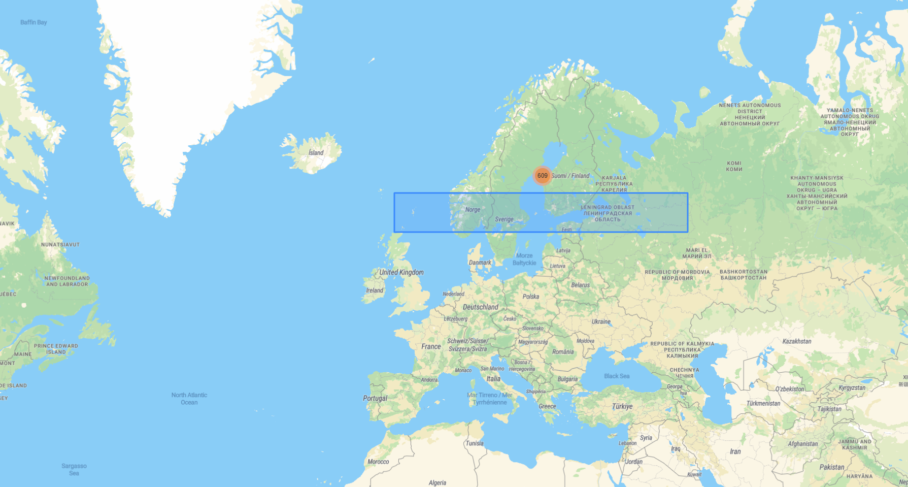
In the following example, I have some stored polygons located over the Baltic sea (between Sweden and Finland). Whenever I draw a polygon over the area where the polygons lie, they are correctly detected, namely all 609 objects are found. (see query and Screenshot_1)
db.geojsons.find({
  location: {
    $geoIntersects: {
      $geometry: {
        type: "Polygon",
        coordinates: [
          [ [17.314453, 61.648162], [17.314453, 64.434892], [26.542969, 64.434892], [26.542969, 61.648162], [17.314453, 61.648162], ],
        ],
      },
    },
  },
});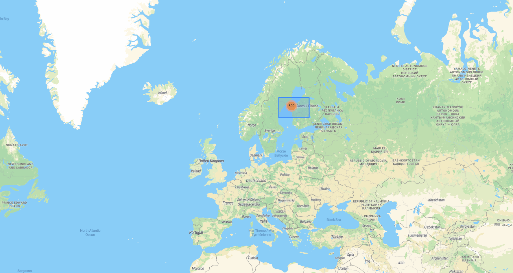
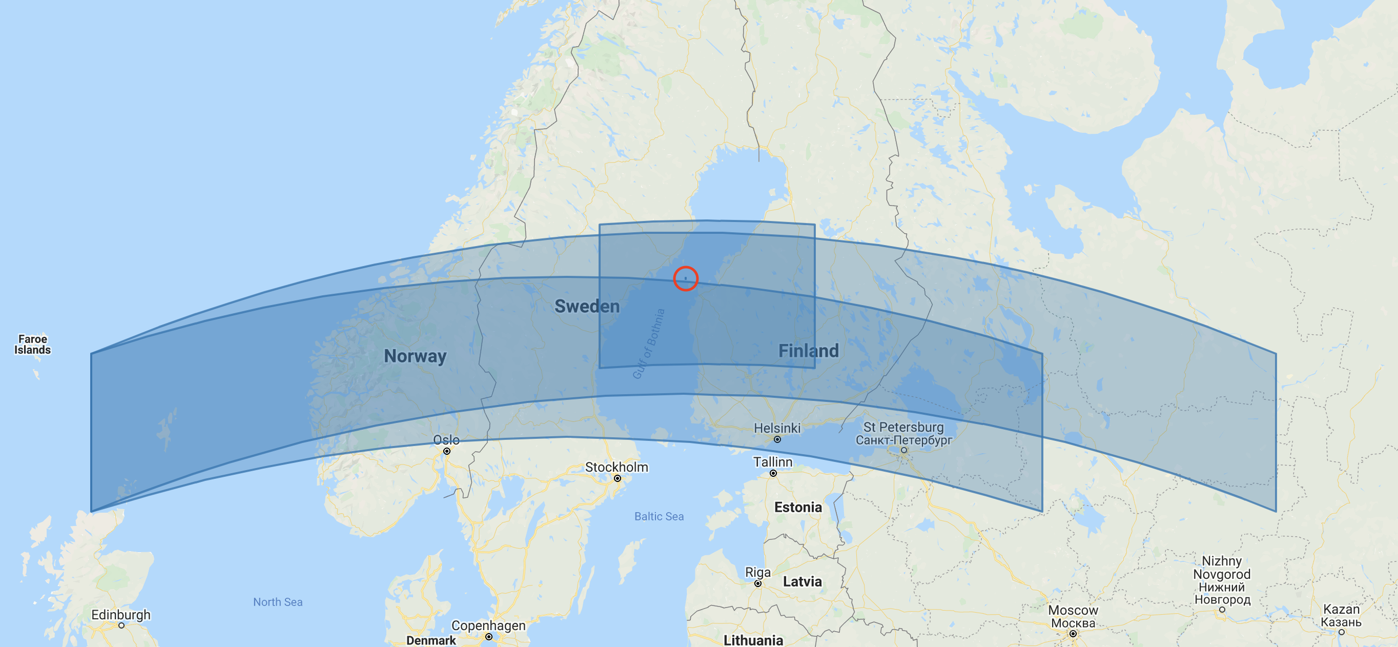
However, the strange behavior occurs when submitting a wider query polygon a little bit below (see Screenshot 2 and 3 with the corresponding queries).
db.geojsons.find({
  location: {
    $geoIntersects: {
      $geometry: {
        type: "Polygon",
        coordinates: [
          [ [-4.482422, 61.93895], [46.318359, 61.93895], [46.318359, 58.585436], [-4.482422, 58.585436], [-4.482422, 61.93895], ],
        ],
      },
    },
  },
});
As well as:
db.geojsons.find({
  location: {
    $geoIntersects: {
      $geometry: {
        type: "Polygon",
        coordinates: [
          [ [-4.482422, 61.93895], [36.318359, 61.93895], [36.318359, 58.585436], [-4.482422, 58.585436], [-4.482422, 61.93895], ],
        ],
      },
    },
  },
});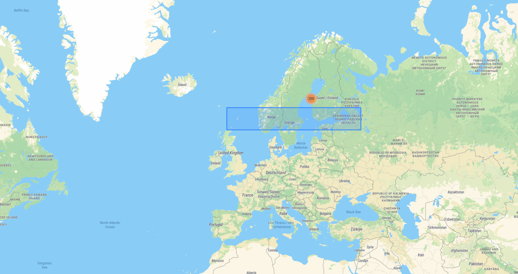
Hereby, I also attach three example GeoJSONs that I use:
{
  type: "Feature",
  location: {
    type: "Polygon",
    coordinates: [
      [
        [20.9995991794984, 63.4348461784678],
        [20.9995991794984, 63.4240745387888],
        [21.0236395339339, 63.4240745387888],
        [21.0236395339339, 63.4348461784678],
        [20.9995991794984, 63.4348461784678],
      ],
    ],
  },
  properties: { acquisitionDate: ISODate("2017-01-13T09:10:31Z") },
  _class: "com.models.database.GeoJson",
};

{
  type: "Feature",
  location: {
    type: "Polygon",
    coordinates: [
      [
        [20.9995993299129, 63.424076492091],
        [20.9995993299129, 63.413304836971],
        [21.0236306669723, 63.413304836971],
        [21.0236306669723, 63.424076492091],
        [20.9995993299129, 63.424076492091],
      ],
    ],
  },
  properties: { acquisitionDate: ISODate("2017-01-13T09:10:31Z") },
  _class: "com.models.database.GeoJson",
};

{
  type: "Feature",
  location: {
    type: "Polygon",
    coordinates: [
      [
        [20.9995994802004, 63.4133067893598],
        [20.9995994802004, 63.4025351187936],
        [21.0236218074932, 63.4025351187936],
        [21.0236218074932, 63.4133067893598],
        [20.9995994802004, 63.4133067893598],
      ],
    ],
  },
  properties: { acquisitionDate: ISODate("2017-01-13T09:10:31Z") },
  _class: "com.models.database.GeoJson",
};
Thank you in advance!
In the following example, I have some stored polygons located over the Baltic sea (between Sweden and Finland). Whenever I draw a polygon over the area where the polygons lie, they are correctly detected, namely all 609 objects are found. (see query and Screenshot_1) db.geojsons.find({ location: { $geoIntersects: { $geometry: { type: "Polygon", coordinates: [ [ [17.314453, 61.648162], [17.314453, 64.434892], [26.542969, 64.434892], [26.542969, 61.648162], [17.314453, 61.648162], ], ], }, }, }, }); However, the strange behavior occurs when submitting a wider query polygon a little bit below (see Screenshot 2 and 3 with the corresponding queries). db.geojsons.find({ location: { $geoIntersects: { $geometry: { type: "Polygon", coordinates: [ [ [-4.482422, 61.93895], [46.318359, 61.93895], [46.318359, 58.585436], [-4.482422, 58.585436], [-4.482422, 61.93895], ], ], }, }, }, }); As well as: db.geojsons.find({ location: { $geoIntersects: { $geometry: { type: "Polygon", coordinates: [ [ [-4.482422, 61.93895], [36.318359, 61.93895], [36.318359, 58.585436], [-4.482422, 58.585436], [-4.482422, 61.93895], ], ], }, }, }, }); Hereby, I also attach three example GeoJSONs that I use: { type: "Feature", location: { type: "Polygon", coordinates: [ [ [20.9995991794984, 63.4348461784678], [20.9995991794984, 63.4240745387888], [21.0236395339339, 63.4240745387888], [21.0236395339339, 63.4348461784678], [20.9995991794984, 63.4348461784678], ], ], }, properties: { acquisitionDate: ISODate("2017-01-13T09:10:31Z") }, _class: "com.models.database.GeoJson", }; { type: "Feature", location: { type: "Polygon", coordinates: [ [ [20.9995993299129, 63.424076492091], [20.9995993299129, 63.413304836971], [21.0236306669723, 63.413304836971], [21.0236306669723, 63.424076492091], [20.9995993299129, 63.424076492091], ], ], }, properties: { acquisitionDate: ISODate("2017-01-13T09:10:31Z") }, _class: "com.models.database.GeoJson", }; { type: "Feature", location: { type: "Polygon", coordinates: [ [ [20.9995994802004, 63.4133067893598], [20.9995994802004, 63.4025351187936], [21.0236218074932, 63.4025351187936], [21.0236218074932, 63.4133067893598], [20.9995994802004, 63.4133067893598], ], ], }, properties: { acquisitionDate: ISODate("2017-01-13T09:10:31Z") }, _class: "com.models.database.GeoJson", }; Thank you in advance! -
None
-
None
-
None
-
None
-
None
-
None
-
None
Hello everyone,
I am currently working on a project, where I store polygons using the native GeoJSON format and then perform geospatial queries to locate these based on both $geoIntersects and $geoWithin operator. Indeed, everything seemed to be working fine.
However, yesterday I discovered a strange behavior, which I am going to reproduce with an example.